

Back in 2010 I performed some static accuracy testing of various GPS receivers. A lot has changed since then, and I wanted to collect some data on current generation hardware.
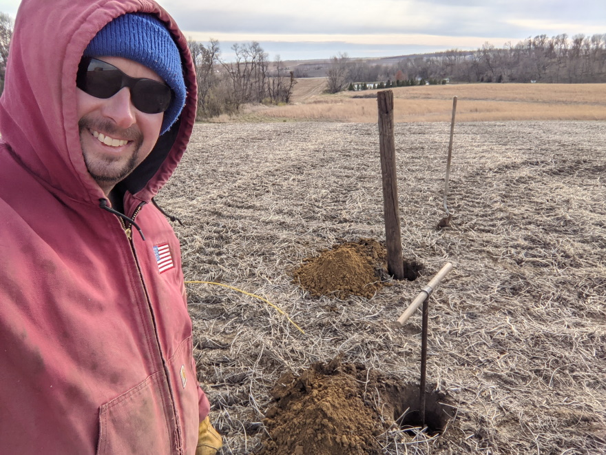
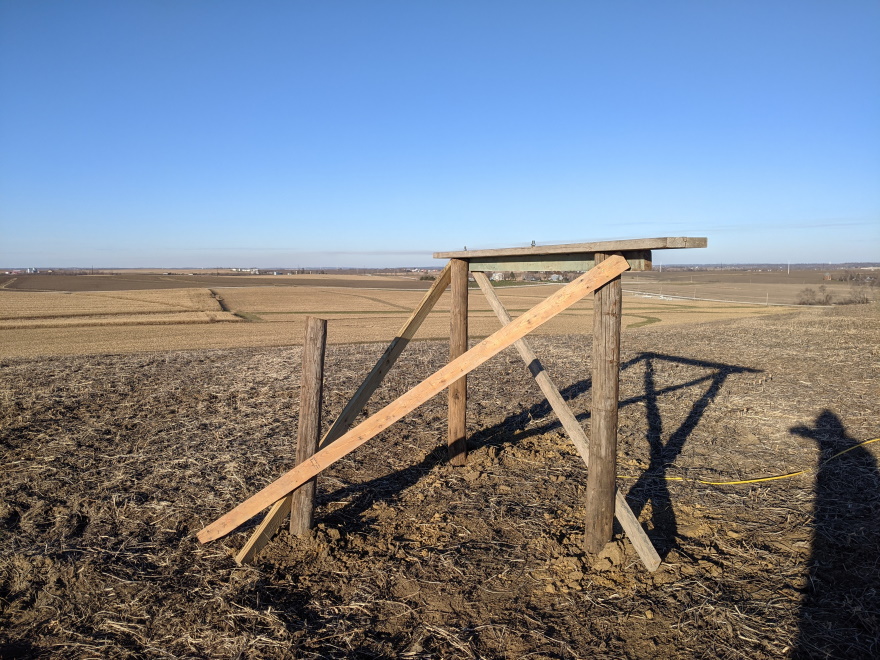
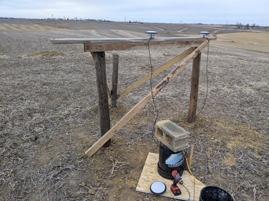
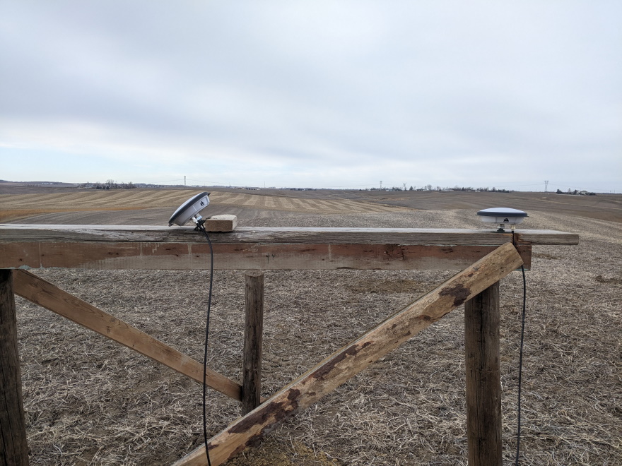
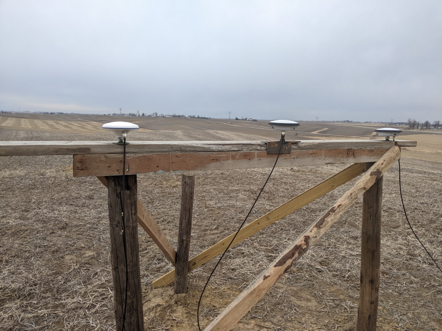
The location I selected for testing is 250 feet from my house, on the ridge line of a hill, with fantastic visibility of the sky in all directions. It is one of the highest elevations in the area. The ground here had been planted to soybeans this year, so no deep grass to deal with. I dug holes 3+ feet deep and placed three wooden posts in a triangle approximately 6 feet on each side. Dimensional lumber was added on top of two of the posts, onto which I mounted the GNSS antennas. The third post was only used as a knee-brace for the others to increase rigidity. I pulled power and Ethernet to this location. For all my testing involving NovAtel PwrPak7 receivers, I used a POE switch and POE to 12v DC power adapters to power the receivers. Data was all fed back to a computer for logging via the Ethernet interface.
Full disclosure - I was not paid to collect this data, nobody asked me to do it, and there were no rules about what can or cannot be posted. I simply wanted to see the performance of various things related to GNSS and Iĺm sharing the results with you.
Test 1 - Does adding Galileo & BeiDou improve accuracy compared to using only GPS + GLONASS
Base station: PwrPak7, GPS+GLONASS+Galileo+Beidou, L1+L2+L5, GNSS-850 antenna.
Rover 1: PwrPak7, GPS+GLONASS+Galileo+Beidou, L1+L2+L5, GNSS-850 antenna
Rover 2: PwrPak7, GPS+GLONASS, L1+L2, GNSS-802 antenna
Conclusion: Adding Galileo and Beidou does improve accuracy by about 40%
Details: I used three PwrPak7 RTK rover receivers. The base and one rover were using the GNSS-850 antenna and had unlocks to support all frequencies and constellations. The other rover was a more common configuration with a GNSS-802 antenna and unlocked for GPS and GLONASS. For correction data I was using MSM4 messages, which is a newer set of messages within the RTCM3 format.
The rover with all 4 constellations had less position drift. Depending on which measurement you want to look at, the movement was 55-65% of the drift seen on the GPS+GLONASS unit. This is a substantial improvement in accuracy.
Note: The first time I did this test I used the Iowa DOTĺs RTN for a base station. The rover with all constellations unlocked showed it was tracking all satellites, but because the data stream didnĺt have data for Galileo and BeiDou, it wasnĺt actually using those satellites. That data set was later discarded and replaced with this one.
Data from GPS+GLONASS
Data from GPS+GLONASS+Galileo+BeiDou
Test 2 - How does tilting the antenna 45 degrees affect accuracy?
Base station: Iowa DOTĺs RTN, nearest base, 8 miles away.
Rover 1: PwrPak7, GPS+GLONASS, L1+L2, GNSS-802 antenna, mounted normally.
Rover 2: PwrPak7, GPS+GLONASS, L1+L2, GNSS-802 antenna, tilted 45 degrees towards south.
Conclusion: Accuracy is slightly decreased by tilting the antenna 45 degrees, but not enough that you would notice. Any system using a tilt sensor to compensate for the machine being tilted would likely have more position error from the tilt sensor calculation than from the antenna orientation. There was a reduction in the number of satellites used in the solution, but the difference was typically just one satellite.
Details: I used two PwrPak7 RTK rover receivers. Both with the GPS+GLONASS L1+L2 unlock and a GNSS-802 antenna. One antenna was mounted normally, the other tilted at 45 degrees towards the south.
RTK correction data was coming from the Iowa DOTĺs RTN using the nearest base station, which is located approximately 8 miles away. This is a pretty real-world comparison for what my customers would commonly be using.
I was surprised at how little the position quality decreased. For most applications, the loss of accuracy due to tilting the antenna is effectively zero. Imagine GPS on a bulldozer working on an extreme slope. Not many machines can stick to a slope at 45 degrees, so this test is beyond the angle that most applications would ever see. Based on the results, I have no concerns about GPS quality when operating a machine on a slope.
Data from normal mounted antenna
Data from 45 degree tilted antenna
Test 3 - How does tilting the antenna 90 degrees affect accuracy?
Base station: Iowa DOTĺs RTN, nearest base, 8 miles away.
Rover 1: PwrPak7, GPS+GLONASS, L1+L2, GNSS-802 antenna, mounted normally.
Rover 2: PwrPak7, GPS+GLONASS, L1+L2, GNSS-802 antenna, tilted 90 degrees towards east.
Conclusion: Position accuracy was substantially worse, but the receiver was somehow able to maintain a RTK fix. The position data had about 3-4x more movement than usual. Satellite visibility was obviously reduced.
Details: I used two PwrPak7 RTK rover receivers. Both with the GPS+GLONASS L1+L2 unlock and a GNSS-802 antenna. One antenna was mounted normally, the other was mounted sideways facing east. This is 90 degrees of tilt and well beyond what would normally ever be seen.
I was somewhat surprised that the position accuracy was as good as it was considering the unusual orientation of the antenna. I would not recommend ever running with the antenna in this orientation, however I will admit the position accuracy is still better than WAAS on a good day.
Data from normal mounted antenna
Data from 90 degree tilted antenna
Test 4 - Does snow affect accuracy?
Base station: PwrPak7, GPS+GLONASS, L1+L2, GNSS-850 antenna.
Rover: PwrPak7, GPS+GLONASS, L1+L2, GNSS-850 antenna
What happens to accuracy when a snow storm rolls in? On January 1st, 2022, we received 4 inches of snow starting around 11am and ending around 8pm. Did this show up in the position data? Is the accuracy for the day any less than a normal day?
Conclusion: No effect. I compared the 24 hour data on the day of the storm to the day before and theyĺre essentially the same. I also looked at the 15 minute drift data on the day of the storm, and you cannot see any change in accuracy during the snow event.
Details: Same base, same rover. Data logged for two consecutive days, one of which had a snow storm during the day.
Data from normal day
Data from a day when it is snowing
Test 5 - 702 antenna vs 850 antenna
Base station: PwrPak7, GPS+GLONASS, L1+L2, GNSS-850 antenna
Rover 1: PwrPak7, GPS+GLONASS, L1+L2, GPS-702-GG antenna
Rover 2: PwrPak7, GPS+GLONASS, L1+L2, GNSS-850 antenna
Is there any difference between a popular antenna from the prior generation (the 702) and the high end antenna from the current generation (the 850)?
Conclusion: Performance is the same.
Details: This is what I expected - the benefit of the 850 is that it can track more signals than the 702, but this test is only using the signals that both antennas can pick up. If you arenĺt utilizing the additional signals that the 850 can get, there is no benefit to using the 850 over the 702. Now if your receiver does support those additional signals, then the benefit of the 850 would be substantial.
Data from 702 antenna
Data from 850 antenna
Test 6 - 702 antenna vs 802 antenna
Base station: PwrPak7, GPS+GLONASS, L1+L2, GNSS-850 antenna
Rover 1: PwrPak7, GPS+GLONASS, L1+L2, GPS-702-GG antenna
Rover 2: PwrPak7, GPS+GLONASS, L1+L2, GNSS-802 antenna
Is there any difference between a popular antenna from the prior generation (the 702) and the the current generation (the 802)?
Conclusion: Performance is the same.
Details: Same as test 5, but with an 802 instead of the 850. The 702 and 802 are pretty close. Would be hard to tell them apart with the data.
Data from 702 antenna
Data from 802 antenna
Test 7 - 502 antenna vs 802 antenna
Base station: PwrPak7, GPS+GLONASS, L1+L2, GNSS-850 antenna
Rover 1: PwrPak7, GPS+GLONASS, L1+L2, GNSS-502 antenna
Rover 2: PwrPak7, GPS+GLONASS, L1+L2, GNSS-802 antenna
For RTK, is there much difference between the 502 and 802 antennas? The 502 is about half the price, and is advertised as a bit less accurate. The recommendation has been if youĺre doing vertical work, get the 802.
Conclusion: The 802 is a bit better by a small margin. The 802 also has a higher number of tracked satellites.
Details: Weĺve been told that the 502 will have ôa few millimetersö more movement than the 802, and this data verifies that. The difference is small enough that for horizontal work like driving a tractor, you wonĺt see it. If youĺre a surveyor looking for the best accuracy possible, stick with the 802.
Data from 502 antenna
Data from 802 antenna
Test 8 - Local base station vs a base 8 miles away
Base station: PwrPak7, GPS+GLONASS, L1+L2, GNSS-850 antenna
Rover 1: PwrPak7, GPS+GLONASS, L1+L2, GNSS-802 antenna, local base
Rover 2: PwrPak7, GPS+GLONASS, L1+L2, GNSS-802 antenna, Iowa DOTĺs RTN, single nearest base
Is there any change in accuracy using a base station from Iowa DOTĺs RTN compared to a local base station? A lot of people using tile plows have a local base because everyone says a local base is more accurate than a RTN. Is it?
Conclusion: There is a big difference. A local base is much better than a RTN base 8 miles away.
Details: The data from the RTN base has approximately 2 to 3 times the amount of movement. That isnĺt to say that using a RTN is bad. Most of what I do is with the RTN as my base, and the accuracy is pretty darn good. In this case, looking at the data in 2D, horizontal movement, 95% of the data points are inside a circle the size of a quarter. Now the local base - 95% of the data points are inside a circle the size of a 9mm bullet. I knew these OEM7 receivers were good, but I didnĺt expect the data to be that tight.
Vertical accuracy and short term drift (15 minutes) is also about 3x better with the local base.
The RTN base I was using is in Newhall which is 7.74 miles west of me.
Data from a local base
Data from a base 8 miles away
Test 9 - Base station at 8 miles away vs 38 miles
Rover 1: PwrPak7, GPS+GLONASS, L1+L2, GNSS-802 antenna, Base is Iowa DOTĺs RTN at 8 miles
Rover 2: PwrPak7, GPS+GLONASS, L1+L2, GNSS-802 antenna, Base is Iowa DOTĺs RTN at 38 miles
How much does the accuracy drop by using a base that is far away?
Conclusion: Position drift with a base at 38 miles is approximately double what youĺd see with a base at 8 miles.
Details: We knew accuracy would be less with a base further away. It's still good enough that you probably wouldnĺt notice the additional position drift when driving A-B lines.
The first RTN base I was using is in Newhall which is 7.74 miles west of me.
The other RTN base I was using is in Tama which is 37.72 miles west of me.
Data from a base 8 miles away
Data from a base 38 miles away
Test 10 - Base station at 8 miles away vs 57 miles
Rover 1: PwrPak7, GPS+GLONASS, L1+L2, GNSS-802 antenna, Base is Iowa DOTĺs RTN at 8 miles
Rover 2: PwrPak7, GPS+GLONASS, L1+L2, GNSS-802 antenna, Base is Iowa DOTĺs RTN at 57 miles
Conclusion: RTK still works with a 57 mile baseline, but it isnĺt pretty.
Details: The long baseline data came from the Iowa DOTĺs RTN, Marshaltown station, which is 57 miles away. Obviously more drift than usual, but if you look at the short term data, there was a lot of drift for about a half hour late in the data capture. Even without that, itĺs obvious that this is far from ideal.
The first RTN base I was using is in Newhall which is 7.74 miles west of me.
The other RTN base I was using is in Marshaltown which is 57.41 miles west of me.
I tried another test with data from Ames (90 miles away) and could not get the receiver to go to fixed RTK. Thatĺs just too far away.
Data from a base 8 miles away
Data from a base 57 miles away
Test 11 - 502 antenna vs 850 antenna on TerraStar C Pro
Rover 1: PwrPak7, GPS+GLONASS, L1+L2, GNSS-502 antenna
Rover 2: PwrPak7, GPS+GLONASS, L1+L2, GNSS-850 antenna
This test is to determine two things: how good is TerraStar-C Pro and how important is the antenna choice when on TerraStar-C Pro?
Conclusion: They were similar in accuracy. The 502 did slightly better with horizontal positioning, while the 850 was slightly better with vertical positioning.
Details: This is a fantastic solution for horizontal work such as autosteer. The horizontal accuracy is pretty close to RTK with a base at 10 miles. The up front receiver cost is less than RTK and there are no radios or base stations needed. Convergence time after boot up is down to a few minutes. And check out the satellite count. TerraStar subscriptions give your receiver a temporary unlock to use all available satellite constellations. During the test I was tracking 24-39 satellites.
As for vertical accuracy, it has more drift than RTK at 40 miles. Obviously it wasnĺt intended for high precision vertical work, and itĺs orders-of-magnitude better than WAAS. I wouldnĺt use it for land leveling or drainage tile.
Data from 502 antenna
Data from 850 antenna
Test 12 - TerraStar-C Pro vs TerraStar-X
Rover 1: PwrPak7, GPS+GLONASS, L1+L2, GNSS-850 antenna, TerraStar-C Pro
Rover 2: PwrPak7, GPS+GLONASS, L1+L2, GNSS-850 antenna, TerraStar-X
This test is to compare the accuracy of TerraStar-C Pro vs TerraStar-X. Normally X is advertised as nearly instant convergence, whereas TSCP takes a few minutes to converge. For this test, the receivers didnĺt reboot. I wanted to see how the accuracy compares after being converged.
Conclusion:
Details:
Data from 502 antenna
Data from 850 antenna
More test data to come soon...
Pictures of the setup
Last updated: April 11, 2022